
Download a pdf copy of all
the latest research that has been carried out on Wheal Victoria at Golitha
Falls:
"Wheal Victoria Copper Mine - History and Remains" by Clive ffitch
(this bookmarked document includes content from all the "History &
Remains", "Further Research", "Underground" and "China Clay
Pipeline" pages)
Photographs taken 2004 to 2019 (and further research 2020)
Sources researched for this page, and for the previous
History and Remains
of Wheal Victoria page, include: "Mines and Miners of Cornwall"
Vol. XII (A.K. Hamilton Jenkin), pub. 1966; plus various other
excerpts from Mining Journals (courtesy of the Cornish Studies
Library, Cornwall Centre) and other quoted sources. Other primary
research included the excellent online mapping resources from the
NLS (National Library of Scotland), and the more recent LIDAR
mapping from Lidarfinder that became available in 2019, plus
specifically, additional evidence taken from on the ground
investigations.
I am also grateful for the use of underground
photos and information in 2011 from Mine Explorer Stuart Dann, and
also “Orphan” of AditNow, plus a walk around Golitha and discussion
with John & Cheryl Manley in 2011.
It is worth repeating the brief introduction to the previous History and Remains of Wheal Victoria page, in that Wheal Victoria is one of those mines that appears to have escaped much modern scrutiny, and rarely appears in books or mining records and references, where even there it is perhaps left as best forgotten. There is however a wealth of history associated with even this relatively small mining adventure, and there is much industrial archaeology and history still left extant in the landscape of Draynes Wood and down at Golitha Falls that is still able to tell a tale or two. The Liskeard Mining District has no mention of it, and the mine is outside the Caradon Mining and World Heritage Site areas. Perhaps the record here will at least try to correct some of these ommisions. So in describing and interpreting the extant features of this mine, I continue with discussing the shafts and adits...
The ENGINE SHAFT (the main or "first" shaft; 1851 to 1853) and FLAT-ROD RUN
The main Wheal Victoria mine shaft, referred to in reports as the Engine Shaft, lies up the steep track up the hill, leading from the open area at the entrance to Golitha Falls. As detailed in Cornish Mining Journal records discussed on the previous History and Remains of Wheal Victoria page, the shaft was sunk sometime between 1851 and 1853, to a maximum shaft depth of 57 fathoms (342 feet), and latest research has now shown that it is virtually beyond doubt that it is this Engine Shaft that was directly linked by a flat-rod run from the First Wheel-pit and water-wheel. These flat-rods would have then operated the mine pump down in the sump of the Engine Shaft, which would have been, and is, linked up at lower levels with the Second Adit that was driven during the same time period, and from which water from the mine was then discharged into the river.
It has been documented that at least one water wheel was used to operate 150 fathoms of flat-rods, which would then put any linked shaft at around a 900 foot-length between the wheel-pit and the shaft. The First Adit is in fact relatively close to the wheel-pits, but it lies at a very inconvenient angle to enable a flat-rod link to be made to it; indeed the visible flat-rod runs themselves do not on the face of it suggest a link to this adit at all, and this is considered as just plain impractical to have achieved. The measured map distance between the First Wheel-pit end of the flat-rods and the access to the Engine Shaft is around 280 metres, which equates to around 918 feet. This matches the requirement of distance.
The evidence that effectively proves the case however, is more recent research with LIDAR mapping (LIght Detection And Ranging, sometimes referred to as Laser Imaging Detection And Ranging). This is essentially 3D mapping of the landscape and underlying terrain, that effectively "sees through" vegetation and structures, to reveal the natural and archaeological features of the ground surface. The technique is very revealing. Using LIDAR mapping that is now freely available online, it can now be shown that the First Wheel-pit was almost certainly linked to the Main Engine Shaft.
The
Main Engine Shaft looking towards the cutaway in the side of the
hollow.
This hollow allowed access for the Flat-rod Run coming up
from the First Wheel-pit
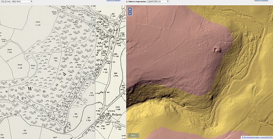
Side-by-side mapping showing the old 25 inch OS Map and a LIDAR map
of the same area.
The flat-rod run has started to reveal itself. Courtesy of
NLS National Library of Scotland online mapping
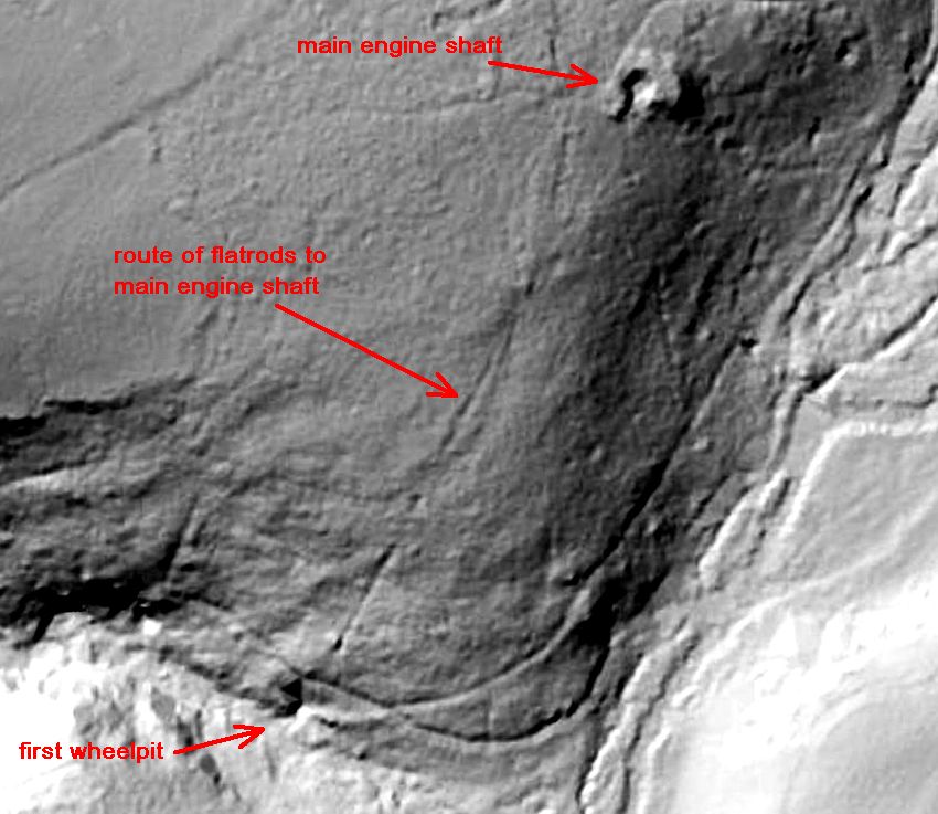
This LIDAR map shows more clearly, with annotation, the direct
alignment of the First Wheel-pit and the opening to
the Engine
Shaft up on the hill. The flat-rod run can also be clearly discerned
leaving the wheel-pit and progressing in direct
line up the hill,
and beyond the old wall in the woods. The flat-rods cross the line
of the wall in two places, and the evident
line becomes less
clear in the upper section, but the destination, with the length of
flat-rods, becomes inescapable.
LIDAR mapping is courtesy of
LIDARfinder online
1m DTM (Digital Terrain Modelling)
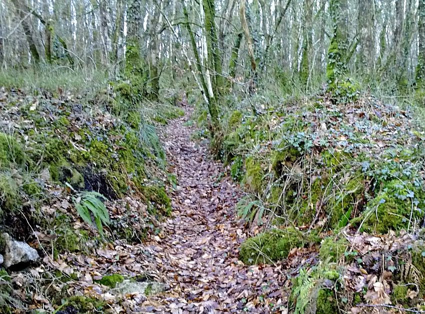
The remains of the Flat-rod Run as seen going up from the First Wheel-pit towards
the top of the hill
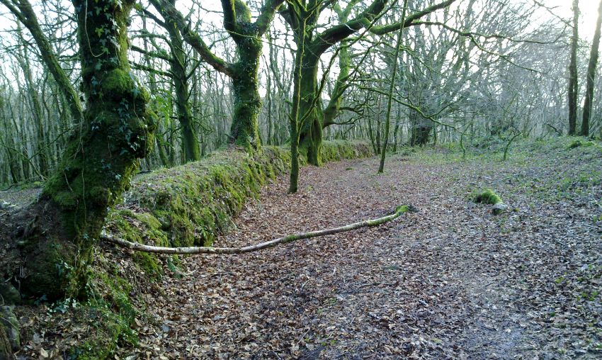
The old wall on top of the hill in Draynes Wood that the flat-rod
run would have crossed.
Th e line of the flat-rods in fact runs
along in the middle distance right of the photo, but without the
LIDAR,
was not readily discernable or convincing on the ground.
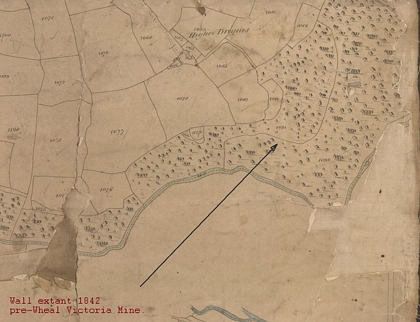
The old wall, with its foundation still able to be identified on the
LIDAR mapping, is a wall that pre-dates the
Wheal Victoria mine,
and is clearly identified on the earlier Tithe Map of 1842
The ENGINE SHAFT (the main or "first" shaft; 1851 to 1853)
There is no sign or indication there was ever an engine here, although this may refer only to a simple horse driven whim - although there is precious little space nearby for that! There is however a small additional hollow adjacent to, and linked to the shaft hollow, that may have accommodated some form of whim or lifting gear that would have served the shaft head, as well as allowing access for the flat-rod run. Access to the mine down the main shaft is most likely to have been via ladders and timber stagings though, rather than by any "man-engine" that could have been operated on the back of large timber rods, as would have been used for the pumping out of water from the mine, pumped out via a lower level, through the Second Adit. This shaft is of substantial size, and would have accommodated a method (hence the need for a whim) to haul up the mine spoil and ore in buckets or kibbles. The flat spoil ground above the natural hillside, that can be clearly identified on the east side of the shaft, is also evidence of this.
The shaft itself has been stated to have been sunk to 57 fathoms (342ft) originally, though this would have long since flooded, and has possibly been part filled with debris, though it has not in any obvious way been significanly run-in.
The Engine Shaft in 2006 showing the spoil ground behind
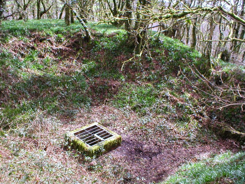
The shaft top is in a gentle hollow by the side of the track, and unusually, it is not capped with concrete, or "choked" (run-in). A grill covers it, and it is possible to peer down into its murky depths. At the top of the hollow is a large flat area overlooking the valley, and across to Redgate, that would have been the top and edge of the mine dumps. This would have been where the waste material was literally dumped at the surface, close to where it was brought up, that had been extracted from both the shaft (when it was sunk), and the mine "levels" (where the "lodes", or viens of ore were worked). Any ore would also have likely been brought up this way in kibbles, unless it was possibly trammed out through the, then, more open First Adit (see details below). The mine shaft itself is now a home to the bats that live in the mine, and this now forms a part of what is now known as the Golitha Falls National Nature Reserve (or NNR), managed by English Nature.
Looking down the Wheal Victoria Engine Shaft
The shaft would
have been large enough for the extraction of mine waste and ore by buckets or
kibbles, as well as
access for the pump rods, powered via the
flat-rod run from the water-wheel in the First Wheel-pit
Another view down the Engine Shaft - there appears a good level of rubbish
and likely flood water.
This shaft from Cornish Mining records
was stated to be down to 57 fathoms (342 feet), so a good deal of
rubbish and possible spoil has gone down here, as well as being
flooded from being sunk below river and water table level
The Engine Shaft is now caged (2016) to prevent access and
provide further protection for the resident bats
Further inspections by Stuart Dann have indicated that this large main shaft is choked with rubbish about 30 feet (5 fathoms) down, and that it was most likely used for hoisting out waste material and spoil, and perhaps later on, ore. Due to its size, such a big shaft may well have incorporated a double skip-way, and also perhaps ladders for the miners' access. The whim for the skip-ways would have been located in the adjacent smaller hollow as previously suggested. The Engine Shaft became, perhaps when completed around 1853, the new primary access shaft to the mine, with its larger skip-ways and ladder-ways, and again perhaps, taking over from the smaller access-only "second" Ladderway Shaft (see below).
Importantly, the Engine Shaft also housed the pumping gear operated by the flat-rod run from the First Wheel-pit. Water would not have been pumped all the way to the surface at the top of this shaft, but would have been discharged via pipework out of the lower Second Adit by the river. This is also evidenced by runs of rusting pipework still visible inside this adit (see below).
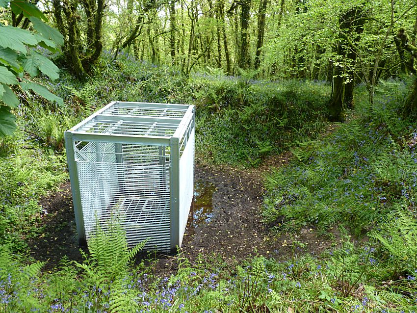
The LADDERWAY SHAFT (the "second" shaft; likely also 1851 to 1853)
There is also a second shaft that can be found hiding itself away, quite well back, and further up into the woods above Golitha Falls. Its location also makes it quite difficult to locate - it is easier in the spring when it is less overgrown, though in recent years it has become very easily identifiable by the rather massive cage now resident over it! The purpose of this shaft was originally unclear, but it is not thought to be as significant as the main Engine Shaft. It lies in a small depression near the edge of Draynes Wood, and is covered by a strong metal grills that allows access for bats, in the same manner as the Engine Shaft. Whether this shaft preceded the Engine Shaft, and was chronologically the first shaft at Wheal Victoria, is also unclear. There is no documented evidence of a shaft being sunk during the first excavations of 1844 to 1846, but that is not to say there was not one. However, given the scale of the Engine Shaft, and the ease of access that would have been facilitated by it, what would have been the purpose of an additional shaft sunk afterwards? This is not a question with any clear answer at this point, other than to present the likelyhood of its purpose being solely for mine access, down what would have been some form of ladderway, whether sunk during the first excavations, or early on in the later excavations.
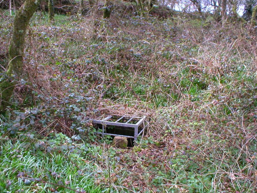
The Second Shaft - the Ladderway Shaft - with its caged top nearly
overgrown
Looking down the shaft itself, the narrow opening lower down implies the shaft was only ever used for limited access by miners themselves - there would have been only just enough room to climb down, if the hole was no bigger originally than it is now - or it was used solely for ventilation. It may have been an early exploratory shaft to determine the extent of the ore-bearing lodes, or to allow access to the First Adit workings that were driven in during the first (1844 to 1846) excavations. Either way, it appears a lesser finished or complex shaft that the larger Engine Shaft.
Looking down the Ladderway Shaft showing the hole in the possible first
sollar, overtopped with earth back-fill,
due likely at least in
part, to the action of badgers previously burrowing nearby and part
choking it
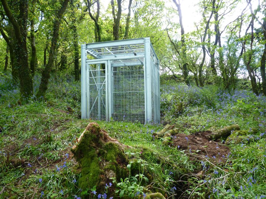
The Ladderway Shaft is also now caged (2016) to prevent access and
provide further protection for the resident bats
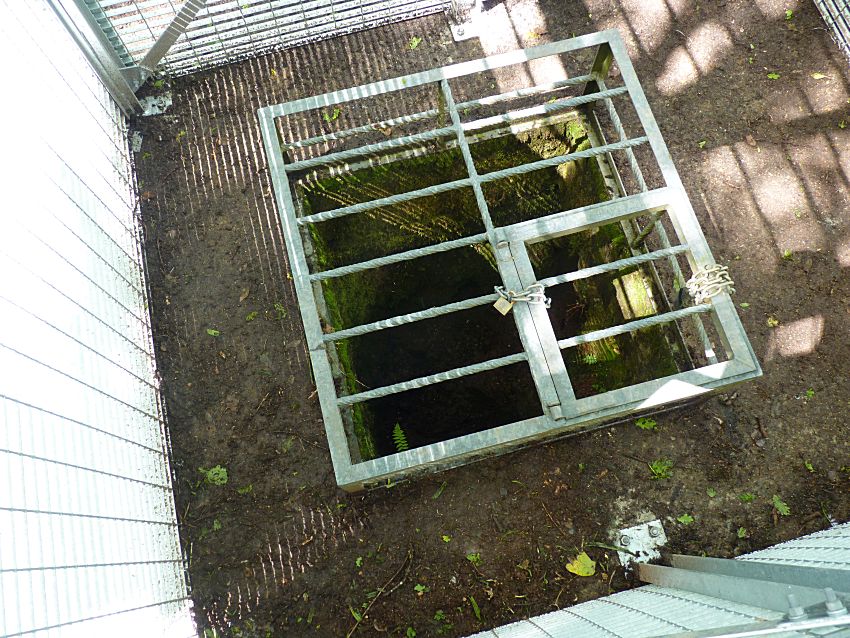
Looking into the shaft through the new protective cage
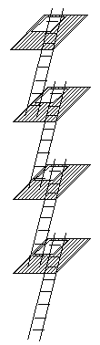 Further correspondence
with Stuart Dann has suggested that this second shaft is in fact a
very nice condition "footway" (or ladder-way shaft), with it's wooden
"sollars" (or wooden platforms supporting the staged ladders) in
place. The ladders would have gone down the shaft in the manner
illustrated on the right, and each successive platform would have
been - may well still be - about 20ft apart. Stuart fully expects
all the ladders to be still in place.
Further correspondence
with Stuart Dann has suggested that this second shaft is in fact a
very nice condition "footway" (or ladder-way shaft), with it's wooden
"sollars" (or wooden platforms supporting the staged ladders) in
place. The ladders would have gone down the shaft in the manner
illustrated on the right, and each successive platform would have
been - may well still be - about 20ft apart. Stuart fully expects
all the ladders to be still in place.
On closer inspection of the photograph above, which was taken looking directly down this Second Shaft, on first sight it just seems to be a tight hole, but it is in fact very likely to be what remains of the ladder-way hole in the first sollar, which has been considerably run in with loose material. This has been increased by a number of animal diggings near the shaft. A much clearer view of this ladder-way access would then be possible (theoretically) if all the earth was removed from the top sollar, thus revealing the extent to which the old miners' footway is still in place, and how much of the old nineteenth century timbers and woodworking may have survived.
Stuart expects that all the underground and Second Adit-level workings would then connect to this ladder-way shaft, and presumably also to the main Engine Shaft. Whether or not these workings connect to the earlier lower level First Adit workings of the earlier excavations during 1844 to 1846, or also extended to the later Second Adit and Engine Shaft workings is purely conjecture.
Representation of a Ladder-way
A Possible THIRD SHAFT (1851 onwards - conjecture)?
According to local knowledge, there was a third shaft that existed somewhere up in the fields above Draynes Wood, that is now on local farmland, which has now presumably been run-in or choked, as there is no obvious marked location evident in the landscape without much closer inspection. The shaft was apparently a substantial affair that over the past century was used as a general dump, and within living memory was eventually filled in for safety, and thereafter the land over and around the old shaft and any workings, reverted back to pasture. This would in itself limit the location to open fields, or at least up on top of the hill on the edge of Draynes Wood. Local first-hand knowledge, from neighbours now sadly passed, can be very valuable in revealing realities on the ground, and there is some evidence that does in fact tie up with this oral record.
There is a slight dip in the ground in the field adjacent to Draynes Wood, that is also highlighted as on the 1882 OS Map (Sheet Cornwall XXVII.SE), but as rough ground, which does not so appear on later OS Maps (as do many a mine shaft find themselves unmapped!). This was investigated on the ground during a walk around Golitha and Draynes Wood with John and Cheryl Manley in 2011.
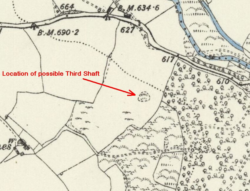
Possible location of a third shaft on the !882 OS Map
Courtesy of
NLS National Library of Scotland online mapping
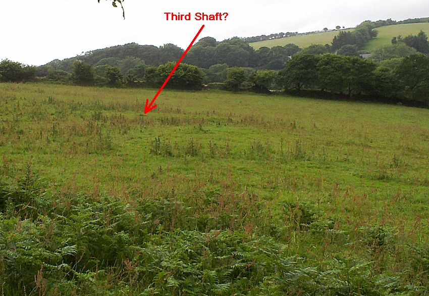
Possible location of the third shaft on the ground, looking out from
Draynes Wood
There also remains the mystery of the flat-rod run from the Second Wheel-pit. On closer inspection of LIDAR mapping, it is possible to see alignments with likely locations of any third shaft. Did this Second Wheel-pit service this possible Third Shaft? Nothing proved, but circumstansial evidence is building a case for it. There are also a couple of other possible locations of this third shaft, as revealed by LIDAR, but none are as yet so convincing.
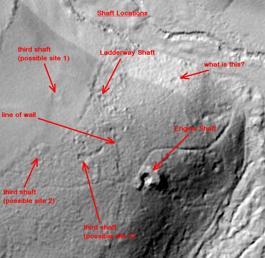
Alternative possible locations of any Third Shaft fro LIDAR - Site 1
is most likely.
LIDAR mapping is courtesy of
LIDARfinder online
1m DTM (Digital Terrain Modelling)
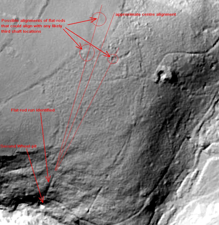
The Second Wheel-pit Flat-Rod alignments with any possible Third
Shaft position.
This would certainly explain the purpose of the
Second Wheel-pit.
LIDAR mapping is courtesy of
LIDARfinder online
1m DTM (Digital Terrain Modelling)
It has previously been suggested that there was in fact also a Fourth Shaft, but this has been pure speculation, and has I think, got itself confused and mixed up with any Third Shaft. I do not believe at this time that there is any case for a fourth shaft, and given the lifespan of the Wheal Victoria mine, I think four shafts would be pushing the reality. Previous suggestions received that suggested that a possible Third Shaft was sited under an aluminium pole and vent pipe above the Send Wheel-pit, that showed signs of being hollow below, is not now believed to be true. The vent pipe (as shown in a photo on the History and Remains of Wheal Victoria page, has been shown to be connected with the China Clay Pipeline running through Golitha Falls Nature Reserve, which has no connection whatsoever with the mine, and indeed its position is only part-way up the flat-rod run, which would not make sense.
Despite the limited amount of documentary evidence relating to the old Wheal Victoria mine that has been found to date, and its apparent smallness in size, the mine itself appears to have had a significant impact on the local landscape, with several shafts, adits, water-wheel pits, and other surface features either present today or known to have existed previously. Golitha Falls, Draynes Wood, and the area around what is now South Draynes, must have had a very different look and feel in the 1850s to the lovely wooded valley and nature reserve that it is now, and the immediate geography of the old working mine, with all of its mine and industry and all the undergrowth cleared, would have appeared far removed from its appearance today. It is through over 160 years of reverting to nature, historical archaeology lost or removed, and now overgrown with undergrowth and trees, that we are left to search for the remaining evidence of what has gone before.
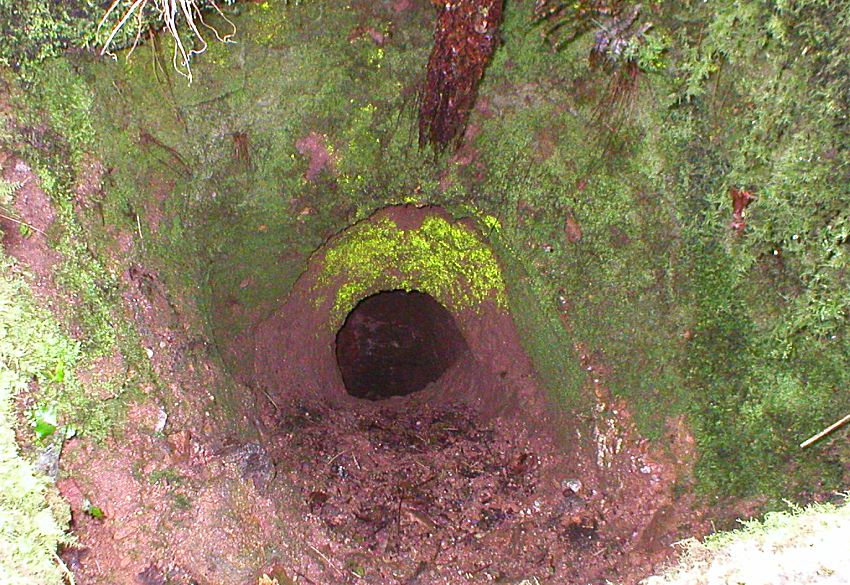
The FIRST ADIT (1844 to 1846 - and the first you will discover)
Thought previously to be the second adit, this has now been identified as the First Adit, driven during the first Wheal Victoria mine excavation between 1844 and 1846. The entrance to this adit can be found not far into the lower woods of the Golitha Falls National Nature Reserve, along the lower paths and tracks, following what has been identified as the lower "Miners' Track". The adit also seems to be very small, and the access cutting is now be blocked by the courses of old leats (water channels) and new paths, and the gated adit itself is now home only to bats. The adit is likely to be well run-in and possibly severely choked further in, but this is difficult to determine as the adit is now well flooded. It appears that it curves slightly to the right and downwards, and likely in the direction of where the two shafts up on the hill were later sited. This adit may well be the full extent of the first excavations, as no shaft is identified as being sunk during these excavations. It is therefore likely that the height of the adit before run-in was at least of man height.
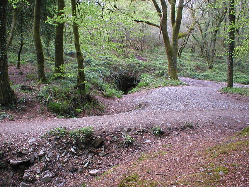
The First Adit - tucked away next to the meeting of paths, with an
old Miners' Track over it
The First Adit entrance, now well run-in
Looking inside the First Adit, flooding is immediately apparent. The adit appears to curve to the right and down, and seems small for regular human access, but this is likely deceiving as, if this was the only access to the early excavations, man-height would have been a requirement. From Mining Journal records, this adit was cleared during the second later excavation of 1851 to 1855 to 70 fathoms (420ft). Was this adit once used to remove ore, as well as likely mine spoil and waste?
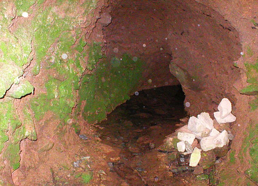
Inside the First Adit (unidentified white rocks partly exagerated
by flash)
Since my initial researches, I have had further information and correspondence from an experienced Mine Enthusiast and explorer, Stuart Dann, who has also looked at this site and suggested that this adit was also in fact one of the main draining points of the mine, and was perhaps also used for tramming materials in, and ore out. As stated, the portal looks like it has probably run in, and become congested with debris. The adit would need to have been draining on a slope for it to function, and therefore much material, now present, would not have been there when the mine was in use.
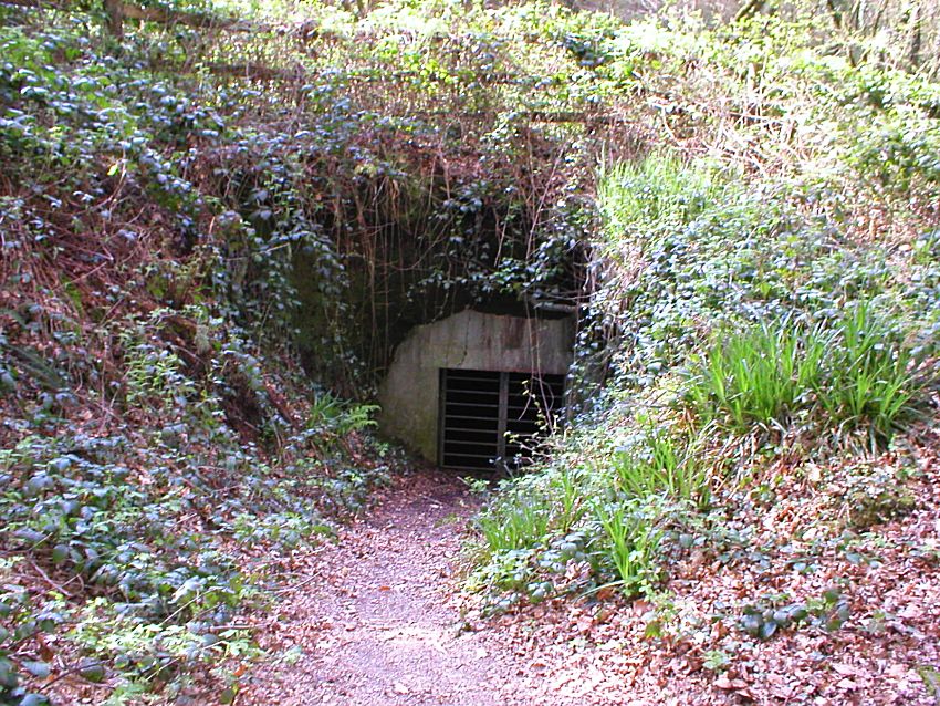
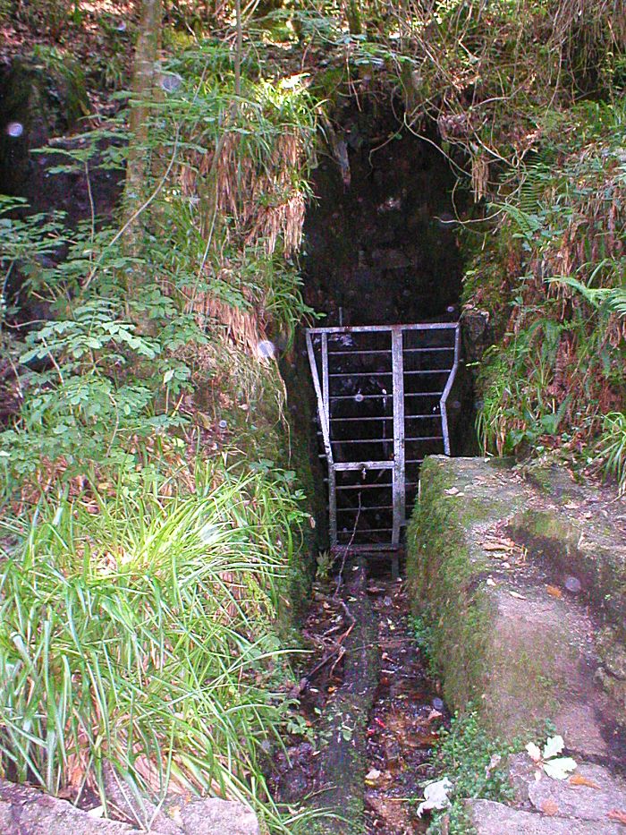
The SECOND ADIT (1851 to 1855)
As with the identity of the other adit, this "Second Adit" was previously thought to be the first adit, but has now been identified as the second adit, driven during the second and final Wheal Victoria mine excavation between 1851 and 1855. This adit is not easily found, being sited in what appears to be a quite inaccessible position by the waterside, in a cleft right down by the edge of the lower falls. It is not in fact very far from the Second Wheel-pit, and can be located right by the waters edge, hidden from immediate view behind the rocks. Again it is well protected, and home now only to the bats. It is very unlikely that any ore was removed by way of this lower adit - there is certainly no evidence of any tramway into it - and the idea of bringing out any ore from way down in the woods by the wheel-pits from here defies both logic and practicality. This adit provided access, but was primarily for drainage of water from the mine pump, in association with the wheel-pits, and flat-rod run to the Engine Shaft, pumping water from the mine sump. This is further evidenced by the rusting pipework still visible within the adit entrance.
As far as access to the adit is concerned, this may well have been via some form of wooden structure providing safer access from the waterside closer to the second wheel-pit. The adit was certainly a significant access portal to the mine, given its walk-in dimensions. It is certainly the best preserved adit, albeit in a precarious location right by the river, but due likely also to its apparently well concealed location.
The cleft in the rock by the side of the river that hides the main
Wheal Victoria Second Adit
(This seems very precariously placed,
but quite possibly had a timber structure added to enable safe
access)
Looking into the cleft and the entrance to the Second Adit hewn into
the granite
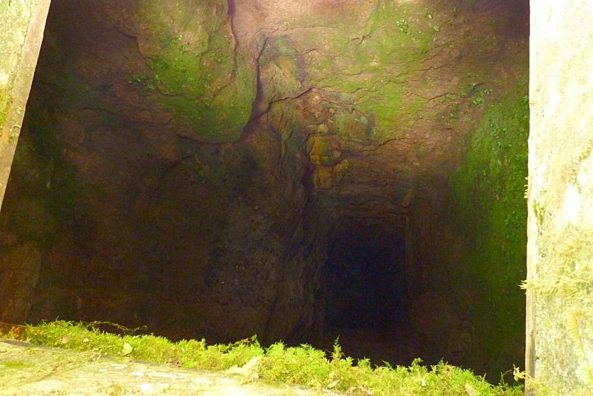
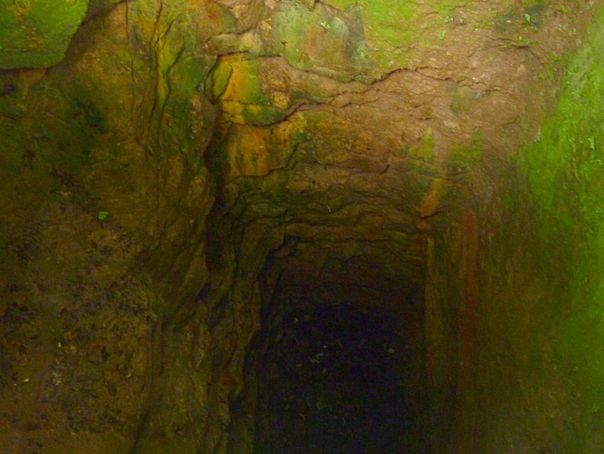
UNDERGROUND in the Second Adit
It is possible to see inside the entrance of this second adit, and into the dark hard-won world of the Wheal Victoria miners of 150 years ago. The access into the adit is man-height, and it is possible to make out where the granite has been drilled and hewn away by hand, and there are old ironwork remains just inside. The amount of work required to open up a simple adit such as this one on the Wheal Victoria mine, where hand chisels, hammers and drill bits were the only tools available, is hard now to appreciate in today's modern age. The remains of old piping and iron work that can still be seen on the floor of the adit, may well have been a part of the equipment used for pumping out the mine workings and mine shafts further in.
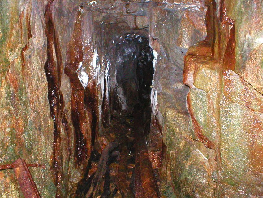
Looking into the
Second Adit and the ghosts of the past.
The height of the adit is clearly made for miners' access, and the
old pipes are likely part of the old pipework for expelling the
pumped out water from the mine out of the adit and into the river
According to local knowledge, there is a large deep area dug out further within the adit, that is now filled with water, that may well have been an "underhand stope" or winze. An underhand stope is a section of a lode that has been dug out downwards, and along the lode, to extract the copper ore, and a winze is in effect an internal mine shaft dug to give access to deeper levels and interconnection to other parts of the mine further in.
This flooded area did indeed turn out to be a winze, as was discovered by experienced mine explorers. To see photographs that were taken during their explorations, and to see what Wheal Victoria is like underground, see the Wheal Victoria Copper Mine Underground page.
DRAYNES BRIDGE and the OLD FORD
It is a misconception that Draynes Bridge was built to service the Wheal Victoria mine. The mine closed in 1855, and the date carved in granite on the centre stone of the bridge clearly states the date of 1876. It may well have been the case that the presence of the mine contributed to reasons for building it in the first place, but the mine certainly never benefited from it. Before the bridge, the old ford just below it appears to have been in common use, and mapping shows the ford in line with the old road or track of the day. This is clearly shown on the Tithe Map of 1842.
What is also clear on the Tithe Map, is that another smaller bridge appears to have existed in place of the 1876 bridge, but this certainly would not have been vehecular, and would at most have catered for foot traffic and possibly horses. The earlier bridge is mentioned in historical records, but no evidence is as yet presented here, other than that of the Tithe Map.
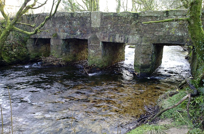
Draynes Bridge - built 1876, by then it was 21 years after the
closure of the mine
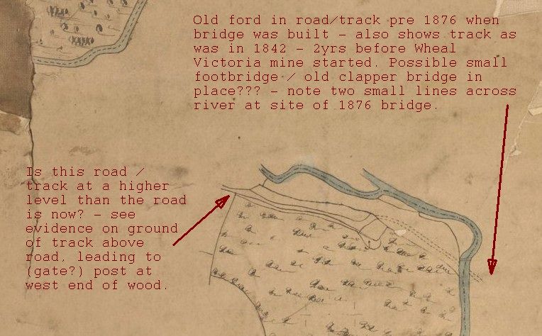
The Tithe Map of 1842 showing the old ford and a possible smaller,
perhaps foot-only bridge
that was in place of the present 1876
bridge
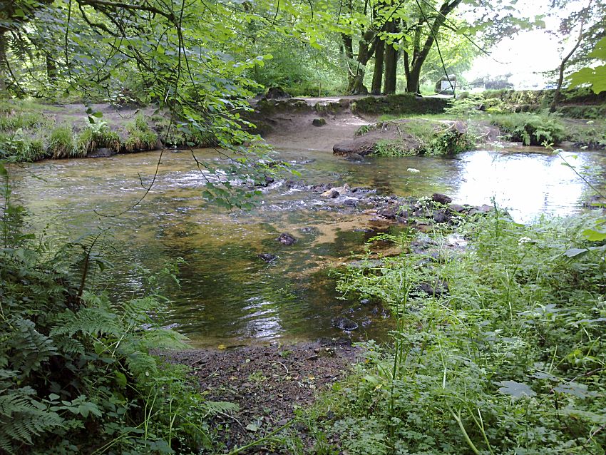
The old ford just below Draynes Bridge - this would likely have been
in use at the time Wheal Victoria was operating
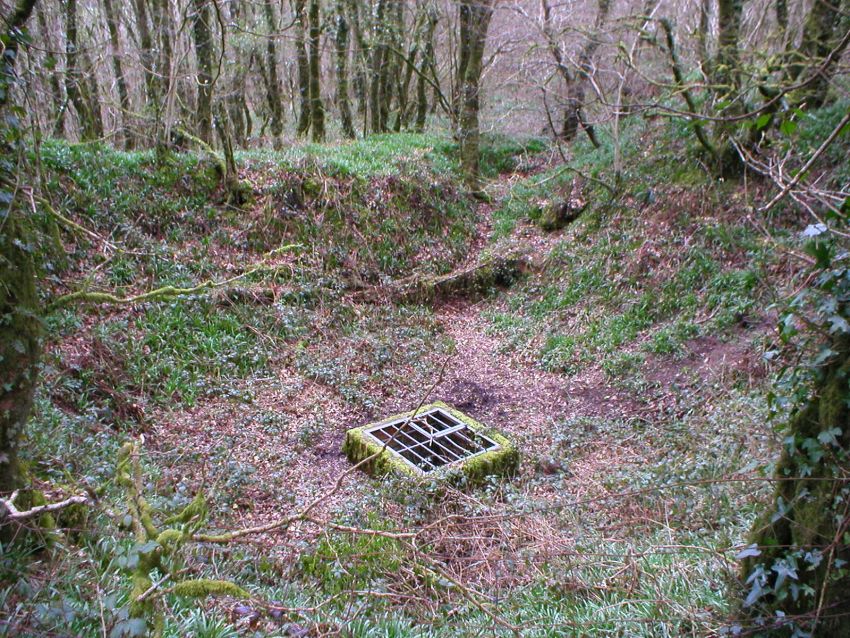
And finally, a little mystery...
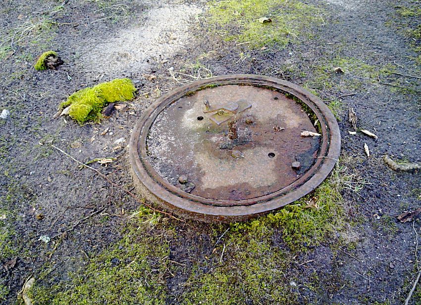
This mysterious circular plate can be found on the ground by Draynes Bridge on the
Draynes Wood side.
What is it, what was it for, and what, if anything, lies under
it?
Sources researched for this page, and for the previous
History and Remains
of Wheal Victoria page, include: "Mines and Miners of Cornwall"
Vol. XII (A.K. Hamilton Jenkin), pub. 1966; plus various other
excerpts from Mining Journals (courtesy of the Cornish Studies
Library, Cornwall Centre) and other quoted sources. Other primary
research included the excellent online mapping resources from the
NLS (National Library of Scotland), and the more recent LIDAR
mapping from Lidarfinder that became available in 2019, plus
specifically, additional evidence taken from on the ground
investigations.
I am also grateful for the use of underground
photos and information in 2011 from Mine Explorer Stuart Dann, and
also “Orphan” of AditNow, plus a walk around Golitha and discussion
with John & Cheryl Manley in 2011.
To see what Wheal Victoria is like
underground, see the
Wheal Victoria
Copper Mine Underground page.
(This page includes some rare
photographs taken by experienced mine explorers - do not try this!)
For more photographs of Golitha Falls themselves, see the Golitha Falls page.
Connect with us, Like us and Follow us on Facebook!
PhotoFile Cornwall supports CoaST and Sustainable Tourism